
North Carolina is bracing for a significant winter storm expected to hit on Wednesday, bringing snow, sleet, and freezing rain to parts of the state. Forecasters predict snowfall of up to 6 inches in some areas, along with hazardous ice accumulations. The storm is expected to create dangerous travel conditions and potential power outages across central and eastern North Carolina.
To prepare for the storm, Governor Josh Stein declared a state of emergency on Tuesday morning, activating the Emergency Response Team. The declaration allows for rapid mobilization of resources to address power outages, icy roads, and other issues caused by the storm.
Where Will the Heaviest Snow and Ice Hit?
Snow and Sleet Accumulation
The National Weather Service (NWS) forecasts snow and sleet accumulations ranging from 1 to 6 inches. The heaviest snowfall is expected along and north of U.S. 64, particularly near the Virginia border and areas from Roxboro to the east, including the Interstate 95 corridor. These regions are under a Winter Storm Warning, which alerts residents to severe weather conditions.
Freezing Rain and Ice Accumulation
Freezing rain could leave up to a quarter-inch of ice accumulation in areas south and east of Raleigh, primarily along and south of the U.S. 64 corridor. Heavy ice accumulation is likely along the I-95 corridor south of Wilson and toward eastern parts of the state. This ice buildup can lead to falling tree branches and power lines, increasing the risk of power outages
Will the Storm Cause Power Outages?
Yes, power outages are a major concern due to ice accumulation. Icy conditions can cause power lines to sag or break and tree limbs to fall onto power lines. Utility provider Duke Energy has already stationed additional repair crews across the state to address power issues promptly.
When Will the Storm Start?
Snowfall is expected to begin in the Triangle region around 11 a.m. on Wednesday, with heavier snow falling by noon. The snow will likely continue until 9 p.m., tapering off by midnight. Light snow showers may persist into Thursday morning, though additional accumulations are predicted to be minor—less than half an inch.
How Will Raleigh, Durham, and Chapel Hill Be Affected?
In the Triangle area, residents can expect a mix of snow and sleet with accumulations ranging from 1 to 3 inches by late Wednesday night. Thursday will see mostly clear skies but will remain cold, with daytime highs around 33°F and nighttime lows dropping to 16°F. Wind gusts of up to 25 mph will make conditions feel even colder, creating dangerous wind chills in the single digits.
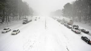
Slippery Roads and Black Ice Warnings
The winter storm is expected to create slippery road conditions from midday Wednesday through Thursday. Drivers should remain cautious, as black ice could form Friday morning and evening. State transportation crews have already pre-treated highways with over 1 million gallons of brine and are staging nearly 500 trucks, plows, and graders to remove snow and ice.
Wind Chill and Arctic Air Warnings
Arctic air will settle across the state, causing frigid temperatures that could last through Saturday. Wind chills on Thursday night are expected to drop into the single digits, making it feel even colder than the actual temperature. Residents are advised to dress warmly and limit outdoor activities during this time.
Be Prepared
Residents in affected areas should take precautions:
- Stay indoors during peak storm hours.
- Charge electronic devices and gather supplies in case of power outages.
- Avoid unnecessary travel, especially during icy conditions.
- Keep pets and animals safe by bringing them indoors or providing shelter.
The storm is likely to cause significant disruptions, but with proper planning and caution, residents can stay safe until conditions improve. For updates, follow the National Weather Service and local authorities for real-time information.
Disclaimer – Our team has carefully fact-checked this article to make sure it’s accurate and free from any misinformation. We’re dedicated to keeping our content honest and reliable for our readers.